
A different shape of Crowdict question
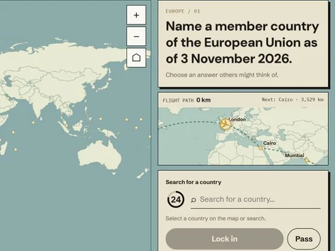
Crowdict Geo takes the familiar Crowd or Rare decision and places it on a world map. Each of its ten questions asks for a country that fits a clue. You can inspect the map, zoom, or search by name before locking in a choice. A correct country earns a band from 10 to 100 points; a wrong answer, pass, or timeout earns zero. The plane moves along a shared route as your score rises. At the end, 1,000 points corresponds to the full 40,000 game-kilometre journey. This guide explains how to combine geography knowledge, careful reading, and the chosen popularity goal.
Geo can be played solo or in a live party. Solo play offers a timed choice or a no-timer setting; timed sessions and parties use a countdown. Choose the no-timer option when you want to explore the map and learn the scope of questions. Choose the timer when you want the pressure and comparability of a quick decision. The scoring idea remains the same: first find a country that fits, then decide whether a familiar or less obvious valid country better suits your selected mode.
Read the clue before touching the map
A world map is full of tempting names. Do not let the visual field replace the clue. A prompt may describe a region, a physical feature, a historical condition, or another factual attribute. Restate the condition before selecting anything. If the question is about landlocked countries, a coastline disqualifies a country no matter how well it fits another part of your mental picture. If the question describes a hemisphere or region, check that the candidate belongs to that scope. Eligibility is the first filter in Geo just as it is in the Daily.
Invented practice example: “Choose a country with no sea coast.” A player might first think of a familiar inland country. Crowd might favor a prominent valid example; Rare might favor a less discussed one. But a small island country is invalid even if it seems obscure. That may sound obvious in a calm reading, yet a timer and a busy map can cause exactly this kind of category slip. The exercise is to translate a verbal condition into a geographic test before deciding which label to tap.
Another invented exercise: “Choose a country in South America.” Start by establishing the region, then compare the salience of eligible countries. Do not let a nearby territory or an adjacent country outside the region enter the shortlist by visual proximity alone. The map is a selection tool, not a substitute for reading. If the display is small, search by country name can be more reliable than trying to tap a narrow shape precisely.
Use map and search as complementary tools
The map is excellent for spatial reasoning. It helps you inspect neighboring countries, coasts, and broad regions. It can also prompt retrieval when a name is on the tip of your tongue. Search is excellent for entering a country you already know, especially a small island or compact state that is difficult to select on a phone. Decide which tool fits the current task. If you are exploring possible answers, inspect the map. If you have a confident candidate, search can reduce selection errors and wasted time.
The creator says the map uses geographic data from Natural Earth. The answer directory includes 193 UN member countries plus Vatican City, Palestine, Kosovo, and Taiwan. This is the game's directory, not a claim that every political or border issue has a simple answer. The creator also notes that boundaries can be complex and the map is a game aid rather than an authoritative political map. For a question with a sensitive or ambiguous boundary, rely on the game's stated scope and the reveal's sources rather than treating the artwork as a final geographic authority.
Zooming helps with small land areas but can hide the larger context. When a question is regional, first orient yourself at a broad scale. Then zoom only if selection needs precision. A common map error is tapping a neighboring country after spending most of the timer reasoning correctly. Search can be a useful final step when accuracy matters more than the satisfying motion of clicking a shape.
Crowd on the map
In Geo Crowd mode, choose a correct country that many players are likely to think of. A large or frequently discussed country may be salient, but size alone is not the scoring rule. The wording of the clue can shift the default. A country prominent in sports might not be the first association for a climate clue; a common travel destination might not fit a physical geography condition. Think of the prompt as a filtered set, then predict the most familiar member of that set.
Try an invented prompt about countries with mountains. A famous mountain country may be an obvious candidate, yet you should confirm the condition rather than infer it from reputation alone. If the clue narrows the feature further, such as a named range or elevation threshold, the familiar candidate may fail. Crowd does not give points for fame independent of correctness. A confident, direct example is stronger than a famous but tenuous association.
Geo reveals the answers and score after you lock in a choice. Treat a lower-than-expected Crowd band as a calibration point. Perhaps another country is more tightly associated with the clue. Perhaps you chose a country familiar to you but not prominent in the game's estimated response set. Avoid turning the result into a universal ranking of countries; popularity is estimated for that question, not for countries in general.
Rare on the map
In Geo Rare mode, look for a correct country that fewer players might retrieve. Regional scanning helps. If the clue allows many countries, move through the relevant area and look beyond the most famous names. But keep an eligibility test attached to every candidate. An obscure country that fails the clue is zero, while a familiar correct country can still score. A useful Rare move is one step beyond the default, supported by a fact you can explain.
Invented practice prompt: “Choose a country crossed by a major river.” A player may think of a widely known river country. Rare invites a less immediate country along a river's course. Yet “near a river basin” and “crossed by the river” may not mean the same thing. The wording should decide the candidate. If your knowledge is uncertain, use a clearer example before the clock ends. The practice prompt is meant to exercise reasoning; it does not assert the game's accepted answer set.
The no-timer solo setting is valuable for building Rare knowledge. Explore regions, read source information in the reveal, and notice countries that fit a clue for reasons you had overlooked. Then try a timed run to see whether you can retrieve the same kind of fact quickly. Slow exploration and fast recall are different skills. The first helps build a mental map; the second is what a timed decision tests.
Points, distance, and the route
Each correct answer receives one of five scores: 10, 25, 50, 75, or 100. Ten perfect 100-point rounds yield 1,000. The game turns the total into progress along a 40,000 game-kilometre route. The route begins in London and follows cities around the world; players follow the same path, so the score determines how far the plane travels. The distance is a visual game measure, not a claim about a flight you have literally planned or a shortcut you can select on the map.
The Daily's rising ×1 to ×4 multiplier pattern should not be imported into Geo. A country answer in Geo uses the themed game's score scale. If you want to compare two Geo results, compare points, distance, mode, and session settings together. A timed party and a relaxed solo run can feel very different even if the scoring bands are drawn from the same broad idea.
The most informative post-round review is often the combination of factual eligibility and popularity estimate. Did you know the geographic relationship? Did you select the intended country cleanly? Did the band match your prediction? These are separate questions. A zero from a wrong selection calls for map or reading practice. A valid low band calls for better mode-specific prediction. One cannot be fixed by the other.
Playing Geo with friends
In a live party, the host chooses settings and shares a room code. Everyone sees the same question and locks in an answer without first seeing the others' picks. When the round ends, the choices are revealed and each plane moves. This makes the comparison more concrete than an abstract leaderboard: you can see the different countries people associated with the same clue. Keep the game fair by letting each person make their own selection before discussing answers.
After a group round, discuss the reasoning rather than just the point gap. Someone may have chosen a familiar country because they thought the clue was narrow. Another may have found a less obvious country from a different region. A surprising zero may come from a mistaken interpretation rather than weak geography knowledge. The shared reveal is a useful teaching moment when the group can separate those causes.
A practical Geo checklist
- Restate the clue as a country test before selecting a map shape.
- Choose a candidate that clearly fits, then rank it for Crowd or Rare.
- Use the map to explore and search to enter a known small or hard-to-tap country.
- Read the reveal's answer scope and sources when a geographic fact is unfamiliar.
- Remember that Geo points and travel distance differ from the Daily total scale.
- In a party, compare reasoning after everyone has locked in a choice.
To play, open the Crowdict Geo page. For the general popularity decision, revisit Crowd mode or Rare mode.
Keep exploring
Practice these ideas in the game, then compare your choices with the reveal. A scoring band is feedback for the next question, not a guarantee about a future answer.